This blog began in late 2006 with the planning and preparation for a circumnavigation of the world in my 39-foot sail boat Pachuca. It then covered a successful 5-year circumnavigation that ended in April 2013. The blog now covers life with Pachuca back home in Australia.

Pachuca

Pachuca
Pachuca in Port Angeles, WA USA

Sunday, October 18, 2015

Day Sail

On Thursday 8 October I took Paul Jr and his uncles Stan and "Celi" for a day sail to Garden Island.  Stan and Celi were over from England to attend the funeral of Paul's father, the man who had renovated the interior of my house and had died suddenly from a massive heart attack.

My master stroke was to book one of the Club's moorings on garden island.  The club owns 8 moorings, freely available to its members, with 2 each at Garden Island, Woodman Point, Rockingham, and the Swan River (which is unavailable to me because of the bridges). 
Paul, Celi at the Helm, Stan on Right

Lunch Time

Paul and Stan

On the Mooring

We met at Fremantle for breakfast at 7 AM (on Paul) then motored out of the marina in light airs at about 9 AM.  Soon we had the headsail up, sailed to the shipping channel, then motored into the wind along the channel to clear the Parmelia and Challenger Banks.  Before clearing the channel we dropped all sail and motored to the mooring, locating it by the its GPS coordinates and photographs provided by the club. 

Once we were secure on the mooring we had a splendid lunch the while Celi and I stayed on the boat dozing off the other two swam to the island for a visit.  The photo will show how close mooring is to the island, perhaps 50 meters. 

To get back we rolled out a bit of headsail for a downwind run in front of a moderate sea breeze and were back in the marina at about 6 PM.

That was the first time that I had used a club mooring and I must say that it was enjoyable to get that close to the shore and feel secure.  The moorings can be booked for several nights and I plan to visit them all in the near future.  Naturally there is a high demand for these moorings during the summer months, particularly during weekends and when school is out, but I'm banking on being able to book the moorings at mid week, one of the perks of being retired.


Galvanizing

Two weeks ago I had Kim Jamieson splice the rope onto the recently regalvanized 30 meters of chain that I had purchased with the Delta anchor.  I then removed the plow anchor and 38 meters of chain from the boat and replaced it with the Delta anchor and chain.  On the way home I dropped the plow anchor and chain at Hartway Galvanizers.

Late last week I picked up the equipment from Hartway and got the following report:

Weight of Plow Anchor: 18 kg
Weight of Chain: 83 kg. 

The total cost @ $3.00/kg came out to $304.01 plus $30.40 GST

This came out cheaper that the $3.50 I had paid for the re galvanization of the Delta anchor's chain, which weighed 67 kg, yielding a total of $234.50 plus $23.45 GST.

The next step will be to try out the new Delta anchor on a sand or mud bottom.  I'll have one of the two Swarbrick anchors (Fisherman or Admiralty type) available with a long rode for weed and rock bottoms. 

I'll store the faithful plow anchor and its re galvanized chain in the garage.


Sunday, August 16, 2015

Delta Anchor

For years I've been thinking about trying out a Delta anchor.  The literature claims that weight for weight they set faster and hold better than plow (e.g. CQR) anchors.

Two weeks ago I was at the club and had a glance at the postings on the bulletin board while I waited for my turn at the coffee machine.  The top item for sale was a 16 kg (35 lb) Delta anchor and 30 meters of 10mm (3/8") chain with another 20 meters of rope attached to it, for $250.
Anchor, Chain, and Rope

16 kg Delta Anchor
I telephoned from Brenda's house and the man told me that he had decided to put a heavier Delta anchor on his Hans 43 and I agreed that a 16 kg Delta seemed a bit light for a 43 ft boat.  He told me that the anchor and rode had hardly been used but the chain had gotten a bit rusty from storage in the anchor well.  He reckoned that the price of a new Delta 16 kg was $330 and the chain another $1000.  I did some Google work and confirmed the price of a new anchor, but the cost of 30 meters of chain varied from just over $200 to close to $1000. 

He lived only a few blocks away from Brenda so I drove to have a look after visiting the boat and taking careful measurement of one of the links on my chain (pitch, width, wire size) because I had to ensure that the new chain would match the gypsy on Pachuca's anchor windlass.

The Delta anchor indeed looked like it had been hardly used.  The chain had superficial rust but the inside of the links showed no wear.  I told him that I had deep concern about the chain because I could not risk the welfare of the boat with anchor chain out of China.  He showed me the "PWB L" stamped on one of the links.  This was good because "L" stood for "Low Carbon".  The rope also looked very good, and that had to be worth at least $100.  I made the purchase and during a short chat afterward it turned out that his Hans 43 is berthed on the other side of D jetty very close to Pachuca, so I expect to see him around.  We both agreed that plow type anchors, including Deltas, are pretty useless over weed or rock but to my surprise he only carries only the one anchor on board because he drops anchor only in sand.  Not me.  I carry at least one Fisherman anchor on board because sometimes you must quickly toss an anchor over the side without the luxury of being able to examine and choose the bottom.

Back at the house I Googled "PWB L" and confirmed that PWB chains are made in Australia to Australian standards.  Last week I dropped the chain off for re galvanizing for about $240.  I could have gotten by with the slight rust on the chain but I could not resist the convenience having the work done before setting the chain up on the boat.

The Delta anchor is 10 lb lighter than the 45 lb plow anchor that I've been using, which will make for much easier handling at the bow.  Between the lighter anchor and shorter (30 m vs 38 m) chain the load at the bow will be much lower, making for better sailing characteristics of the boat.  The 20 m of rope will be spliced at the end of the chain so that I can move the rode from the gypsy to the drum for paying out the rope.

In the coming season I'll evaluate the setting and holding properties of the anchor as well handling the rode.  I'll also have the 38 m of chain currently in the locker re galvanized.


Notice to Mariners

The following is a message that I recently sent to the FSC Cruising Section:

About three weeks ago Kim Klaka notified me of his success in his effort to have the DOT issue a Ntm regarding changing bathymetry of the Parmelia and Success banks during winter.

See notice 48 at http://161.152.28.103:10003/pls/lweb/notice_info?p_chart_id=WA%20001
Notice 48 is at the end of the above document, and states:
------------------------------
--

48. Insert
Text CAUTION (See note 8) in positions
32° 04.28' S   115° 39.34' E
32° 07.71' S   115° 40.85' E
and text
8.  Parmelia and Success Banks are subject to seasonal shoaling, mariners are advised to navigate with caution. in position
31° 53.78' S   115° 46.60' E

------------------------------
-
I hope that this notice will find its way to the next edition of the relevant DOT charts.

 The NtM appears vague because it is dealing with a vague problem.  However, to an experienced sailor in unfamiliar waters the phrase "seasonal shoaling" will jump out of the chart in large bold lettering.


Monday, June 29, 2015

Pachuca OK

I visited Pachuca this weekend, two weeks after the grounding.  As I approached her I kept a wary eye on her water line and she seemed to be riding as high in the water as ever.  Once inside the cabin I started the electric bilge pump which began sucking air almost immediately.

So as I had expected, the boat is not taking water, and I am confident that the only damage from the recent grounding is to the anti fouling at the bottom of the keel.

Our legendary sailor Jon Sanders ran into his own boat problems during the week.  The boat that he was delivering began taking more water than the pumps could deal with in very rough seas.  There was a hole in the deck, two skin fittings (which are below the water line) failed, and there must have been another leak elsewhere.

Jon cannot be faulted because he was only delivering the boat and would not be expected to make a full survey of the vessel.  Incidentally, I had every skin fitting (aka thru-hull fitting) replaced on Pachuca at great expense before setting off around the world. 

http://www.abc.net.au/news/2015-06-28/renowned-sailor-jon-sanders-blames-huge-swell-for-yacht-rescue/6579042


Thursday, June 25, 2015

Grounding Aftermath

There has been some progress in chart issue raised by my recent grounding.  The following was the response to my request for the coordinates of the grounding.  Having that information enabled the sending of the subsequent message to DOT (WA Department of Transport). 


And the following message has been sent to the DOT by one of the members of the FSC Cruising Section.  (An NtM is a Notice to Mariners.)  (Also, note that "a depth of 1.9m some distance to the west of the grounding location" in the text would still have been OK for my boat, given that the water level was at 0.7m above, datum - yielding an actual depth at that time of 2.6m.)

Dear Sir/Madam,
I wish to draw to your attention a  region that has been reported as significantly shallower than charted. On Sunday 14th June the yacht Pachuca went aground on Parmelia Bank between Carnac and the channel at 32 07.3S, 115 40.7E. The details of the incident are reported in the yacht blog at http://pachucaroundtheworld.blogspot.com.au/2015/06/grounding.html
The yacht draws between 2.3m and 2.4m so the depth at the grounding location, after account for tide height and storm surge, was less than about 1.7m. The chart sounding nearest  the location appears to be 4.6 m, with a depth of 1.9m some distance to the west of the grounding location.
Many locals know that both Parmelia and Success Banks often change bathymetry after storms, usually during winter. It is therefore perhaps unreasonable to expect these areas to be surveyed after every winter with the severe budget constraints currently being experienced by government agencies. However, in the interests of safety may I suggest two (inexpensive) actions:
1.       When the next edition of chart 001 is printed, include an additional caution to the effect that those two banks often end up shallower after storms, so extra caution should be exercised if travelling over them.
2.       Given that the next edition could be some time away, issue a NtM with the same cautionary note.

Cockburn Volunteer Sea Rescue have already issued a similar warning on their Facebook page: “NAVIGATION WARNING: Please note the charted depth in the area of 32 07.300S, 115 40.700E is inaccurate and can be less than one meter deep depending upon tide. Mariners are advised to navigate with caution in the area.”  source: https://www.facebook.com/CVSSR/photos/a.568131439874686.1073741825.524373530917144/981368245217668/?type=1

On a related matter, I note that none of the listed corrections to chart 001   http://161.152.28.103:10003/pls/lweb/notice_info?p_chart_id=WA%20001  includes reference to the shallow patch of 1.8m reported to DoT in 2012 and 2013, for which an AHS NtM (119 for chart 754) was issued in January 2014. It behoves DoT to issue a parallel chart correction notice, as that shallow spot causes winter swell to break on it, making it a very serious hazard when the swell is up and from the westerly quadrant.

NOTICES TO MARINERS for Aus754
-----------------------------------------------
119* WESTERN AUSTRALIA - Success Bank - Depth.
Fremantle Ports (DHDB 2566728) ( )
 Aus754 [1052/2013]
Insert    depth, 1.8m, enclosed by contour            32° 04.997 S  115° 42.917 E
Delete  depth, 4.1m       32° 04.900 S  115° 42.900 E

Monday, June 15, 2015

Grounding

Last weekend I ran aground hard on the Parmelia Bank, east of Carnac Island.

I had arrange to have a sail with Paul on Sunday because the forecast was for clear weather and a moderate SE wind.  I was up at 4 am, picked him up at his place in Chidlow at 6 AM, and we were in Fremantle at 7 AM.  The boat was ready to go because a few days earlier I had reassembled the LPG system and the day before topped up the tanks with 45 liters of diesel.  We set off for South Passage, between Garden Island to the south and Carnac island to the north in order to get out of Cockburn Sound and sail along the west side of Garden Island.

As we passed along the east of Carnac Island over the Parmelia Bank I kept an eye on our position and SE track mindful of the rocks to the south of the island.  We were making about 5 kts under full mainsail and half of the jib rolled out, with a 12 kt breeze off our port beam.

The shallow water alarm went off and before I could react we were bumping along the bottom under sail.  By the time we dropped the sails we were well into the shallows with the boat regularly rising up then bumping back on to the bottom in the gentle swell.  Fortunately the Parmelia Bank is of sand and weed, so I was not too concerned about structural damage to the hull, but nevertheless it was very unpleasant to experience that incessant thumping of my boat onto the bottom,

I had two problems with the situation.  First, I could not tell the best direction to take for the deeper water.  Even if I did know the best direction, the boat did not respond well to the propeller, whether forward or aft.  I churned up a lot of sand but got little movement and worse, had no control of the direction of movement.

Had we been isolated I would have checked the tide and confirmed my suspicion that it was falling and would not reach its next high for almost 24 hours, launched the inflatable, surveyed the area for the closest deep water, rowed out and dropped the anchor then kedged our way out by winching the boat along the anchor chain using the engine to help us along, with the boom out to the lee side to try to get the boat to heel over and reduce its draft.  But we were in Cockburn Sound.

 I got on the VHF radio and hailed VN6DI on channel 73.  In 20 minutes a boat from Cockbun Sea Reacue was at our side.  They surveyed the best way out (pretty much the way we had come in), tossed a heavy harness which we passed on each side of the head stay and made fast to my strongest cleat,  and dragged us for several minutes through the bank into deeper water.

While waiting for the rescue boat I had been wondering how I could have been so careless in my navigation.  After the crisis was over I would have to carefully analyze what had gone wrong.  Then one of the men in the rescue boat mentioned that the water in this area was shallower than indicated in the chart.  That was very interesting.

The incident knocked the stuffing out of me regarding sailing, and in any event I judged it too risky to venture out into the open sea west of Garden Island without being completely sure that the boat had not been damaged.  But as we approached Fremantle I started feeling better and we spent another 3 hours doing a very pleasant sail to the north along the coast then back south into the marina.

Back at the club ran into one of the two men that had been sent out by the club in a RIB to assist us and he told me that in winter the Parmelia Bank increases in height and it can get as shallow as 1 meter.  My reaction was along the lines of  'What???  Isn't the chart supposed to show the guaranteed minimum at the LAT (Lowest Astronomical Tide)?  Nobody has ever told me about this!"  The man told me that they used to actually surf over that bank in one of the club's wood hull boats.  His last words to me were that it can happen to anybody.  I replied that I might head back to Cape Horn, which seemed safer than Cockburn Sound.

Looking back, I can see the trap that I got into.  First of all, I relied on the chart.  But because I had not done any winter sailing in that area and had not hung around the club enough to get the vital information by word of mouth the stage had been set for the second (the first was with my 27-ft sloop Angie) and by far the worst grounding. 

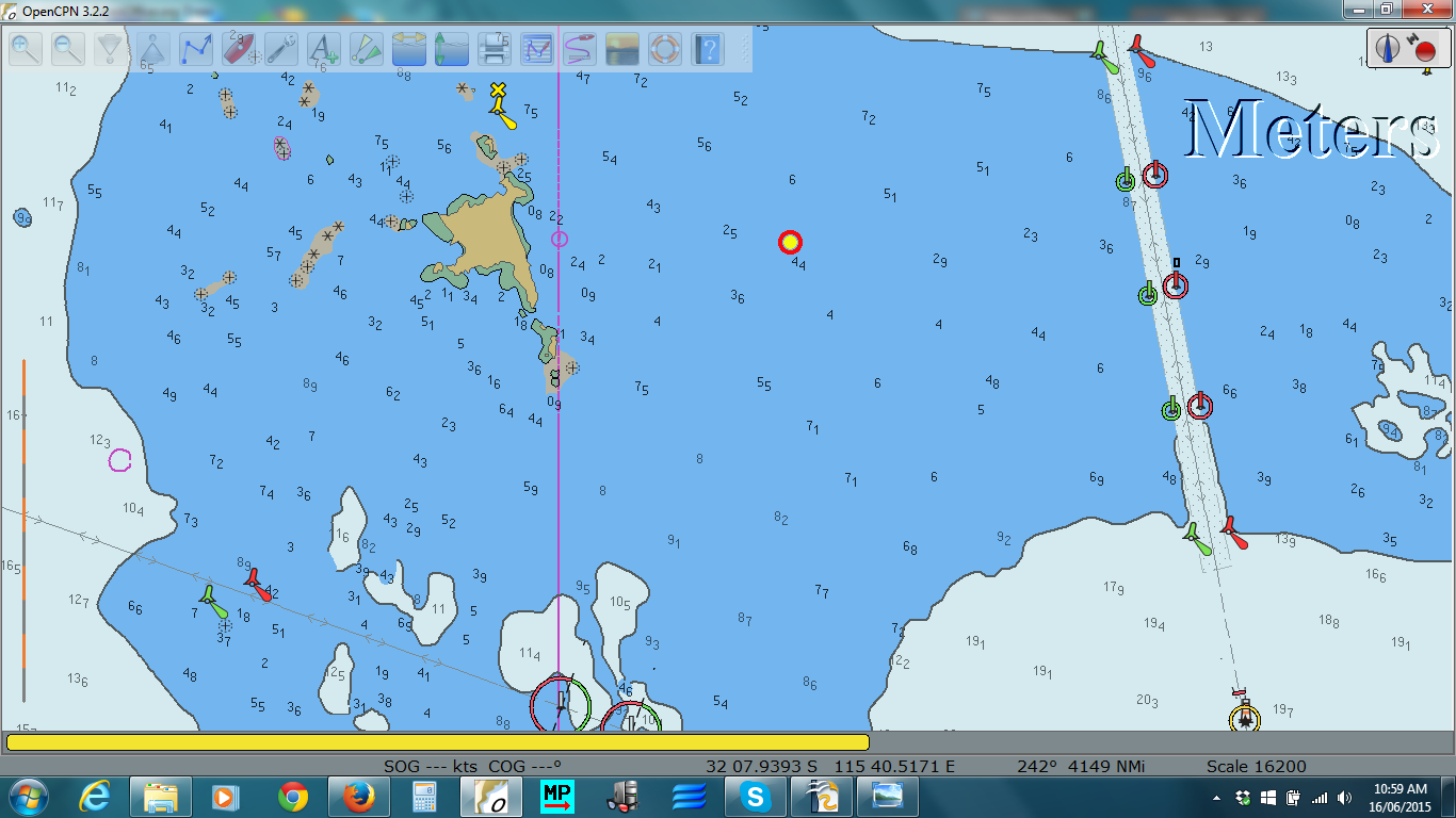
Red Circle Marks Approximate Location of Grounding

South Passage between Carnac and Garden Islands


The first image shows a closeup of the area of the grounding.  In that tide I should have been able to clear anything above 2 meters on the chart.

The second image shows South Pass, with Carnac Island to the north and the larger Garden Island to the south.  To the right is the shipping channel.   The two circled leads mark the deepest route through the pass.  Sail boats can normally pass between the line of those leads and the rocks just south of Carnac Island.

Blog Archive

Contributors

Statistics Click Me