
I had arrange to have a sail with Paul on Sunday because the forecast was for clear weather and a moderate SE wind. I was up at 4 am, picked him up at his place in Chidlow at 6 AM, and we were in Fremantle at 7 AM. The boat was ready to go because a few days earlier I had reassembled the LPG system and the day before topped up the tanks with 45 liters of diesel. We set off for South Passage, between Garden Island to the south and Carnac island to the north in order to get out of Cockburn Sound and sail along the west side of Garden Island.
As we passed along the east of Carnac Island over the Parmelia Bank I kept an eye on our position and SE track mindful of the rocks to the south of the island. We were making about 5 kts under full mainsail and half of the jib rolled out, with a 12 kt breeze off our port beam.
The shallow water alarm went off and before I could react we were bumping along the bottom under sail. By the time we dropped the sails we were well into the shallows with the boat regularly rising up then bumping back on to the bottom in the gentle swell. Fortunately the Parmelia Bank is of sand and weed, so I was not too concerned about structural damage to the hull, but nevertheless it was very unpleasant to experience that incessant thumping of my boat onto the bottom,
I had two problems with the situation. First, I could not tell the best direction to take for the deeper water. Even if I did know the best direction, the boat did not respond well to the propeller, whether forward or aft. I churned up a lot of sand but got little movement and worse, had no control of the direction of movement.
Had we been isolated I would have checked the tide and confirmed my suspicion that it was falling and would not reach its next high for almost 24 hours, launched the inflatable, surveyed the area for the closest deep water, rowed out and dropped the anchor then kedged our way out by winching the boat along the anchor chain using the engine to help us along, with the boom out to the lee side to try to get the boat to heel over and reduce its draft. But we were in Cockburn Sound.
I got on the VHF radio and hailed VN6DI on channel 73. In 20 minutes a boat from Cockbun Sea Reacue was at our side. They surveyed the best way out (pretty much the way we had come in), tossed a heavy harness which we passed on each side of the head stay and made fast to my strongest cleat, and dragged us for several minutes through the bank into deeper water.
While waiting for the rescue boat I had been wondering how I could have been so careless in my navigation. After the crisis was over I would have to carefully analyze what had gone wrong. Then one of the men in the rescue boat mentioned that the water in this area was shallower than indicated in the chart. That was very interesting.
The incident knocked the stuffing out of me regarding sailing, and in any event I judged it too risky to venture out into the open sea west of Garden Island without being completely sure that the boat had not been damaged. But as we approached Fremantle I started feeling better and we spent another 3 hours doing a very pleasant sail to the north along the coast then back south into the marina.
Back at the club ran into one of the two men that had been sent out by the club in a RIB to assist us and he told me that in winter the Parmelia Bank increases in height and it can get as shallow as 1 meter. My reaction was along the lines of 'What??? Isn't the chart supposed to show the guaranteed minimum at the LAT (Lowest Astronomical Tide)? Nobody has ever told me about this!" The man told me that they used to actually surf over that bank in one of the club's wood hull boats. His last words to me were that it can happen to anybody. I replied that I might head back to Cape Horn, which seemed safer than Cockburn Sound.
Looking back, I can see the trap that I got into. First of all, I relied on the chart. But because I had not done any winter sailing in that area and had not hung around the club enough to get the vital information by word of mouth the stage had been set for the second (the first was with my 27-ft sloop Angie) and by far the worst grounding.
 |
| Red Circle Marks Approximate Location of Grounding |
 |
| South Passage between Carnac and Garden Islands |
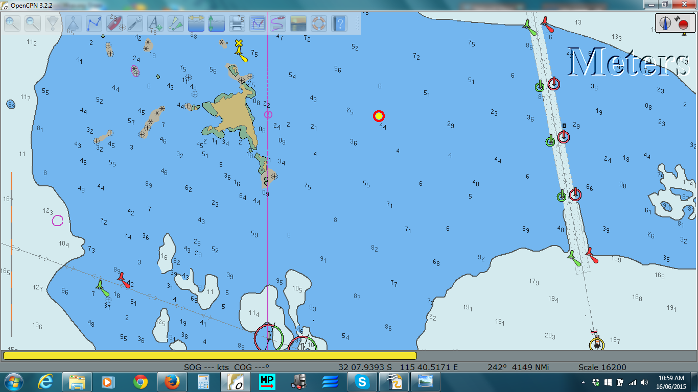
The first image shows a closeup of the area of the grounding. In that tide I should have been able to clear anything above 2 meters on the chart.
The second image shows South Pass, with Carnac Island to the north and the larger Garden Island to the south. To the right is the shipping channel. The two circled leads mark the deepest route through the pass. Sail boats can normally pass between the line of those leads and the rocks just south of Carnac Island.
1 comment:
Local knowledge is that the sandbanks in Cockburn Sound East of Carnarc Island move around considerably in winter, and even in summer the chart datum is unreliable. We've touched bottom several times over the years, and racing yachts with full spinnakers have also come to sudden stop, even with full-time navigators keeping watch.
Post a Comment